
Rīgas Spilves rogainings (01.04.24)
Programme Getting there and competition center Map and legends
DESCRIPTION
Spilves are plants of the sedge family with white and fluffy flowers, which proliferated in the Spilve meadows after 1755, when the Lielupe river opened a new inlet into the sea, and the former inlet in the Daugava near Spilve became swampy. In dry weather, local farmers graze cattle and mow hay here. During the First World War, airplanes landed in Spilve meadows until the countryside was bombed. In 1922, it was renovated by creating the "Spilve air port", which was mainly used by the Latvian Post and Telegraph Department. At first, flights took place on the route Tallinn-Riga-Memel-Königsberg-Danzig-Berlin, but later also on the route Helsinki-Tallinn-Riga-Vilnius-Warsaw-Lviv-Bucharest-Sofia-Thessaloniki-Athens-Palestine.
.jpg)
.jpg)
.jpg)
.jpg)
EVENT SCHEDULE
| Time | Actity |
|---|---|
| 09:30 | Begins issue of competitor bibs and maps |
| 11:00 | Start for 6h rogaining (participants of the Rogaining hike can start the distance from 11:00 to 13:00) |
| 11:30 | Start for 3h MTB rogaining |
| 12:00 | Start for 4h rogaining |
| 13:00 | Start for 2h rogaining, 2h rogaining run un 2h rogaining walk |
| 14:30 | Control time end for 3h MTB rogaining |
| 15:00 | Control time end for 2h rogaining un 2h rogaining run |
| 16:00 | Control time end for 4h rogaining |
| 17:00 | Control time end for 6h rogaining un Rogaining hike |
| 17:10 | Begins prize giving for classes. INTERVALS.LV lottery withr Garmin and other prizes. |
COMPETITION CENTER LOCATION
TERRAIN
GPS ROUTE RECORDING AND ANALYSIS AFTER COMPETITION
 If you want fans to follow you during the race, watching on the big screen in the center of the race, or after the race to analyze your (or your competitors') wandering around the right checkpoint, use the MapRun smartphone application:
- iPhone version: https://apps.apple.com/us/app/maprun/id1634949963
- Android version: https://play.google.com/store/search?q=maprun&c=apps
- Garmin version: https://apps.garmin.com/en-US/apps/05fa6a5e-e9e6-4865-8b3b-0b8a3c64eeba
- Open the application > Name > Write down your name, surname, gender, age > Accept > Select Event > Latvia > Pilsetas_legendas > "Event name" (scan this QR code or click on this link) > Ok (may have to wait ~20 seconds while loading) > Go to Start
- Turn on the GPS function on your smartphone just before the starting shot.
When you get within 15 meters of the start or checkpoints or the finish at the end, they will turn green (counted) but your smartphone will beep/vibrate (after that you can keep your phone in your pocket or bag without pulling it out until the finish, as long as you hear your phone beep at each checkpoint - it means that the application works successfully). - You can also use your GPS wristband instead of your phone by uploading your GPX route here after the finish: http://www.p.fne.com.au/#/gpsupload
- The routes will be available here: https://p.fne.com.au/rg/cgi-bin/SelectResultFileForSplitsBrowserFiltered.cgi?act=fileToSplitsBrowser&eventName=ScoreResults_Liepajas%20Dienvidu%20Fortu%20Rogainings%202024%20Start%20Anywhere%20PXAS%20ScoreP360%20PZ0820042024.csv
- If the MapRun app didn't count a checkpoint for you, then press: Show Results > select the rogaining you just ran > Review Results (HITMO) and indicate the missing checkpoints!
DESCRIPTIONS
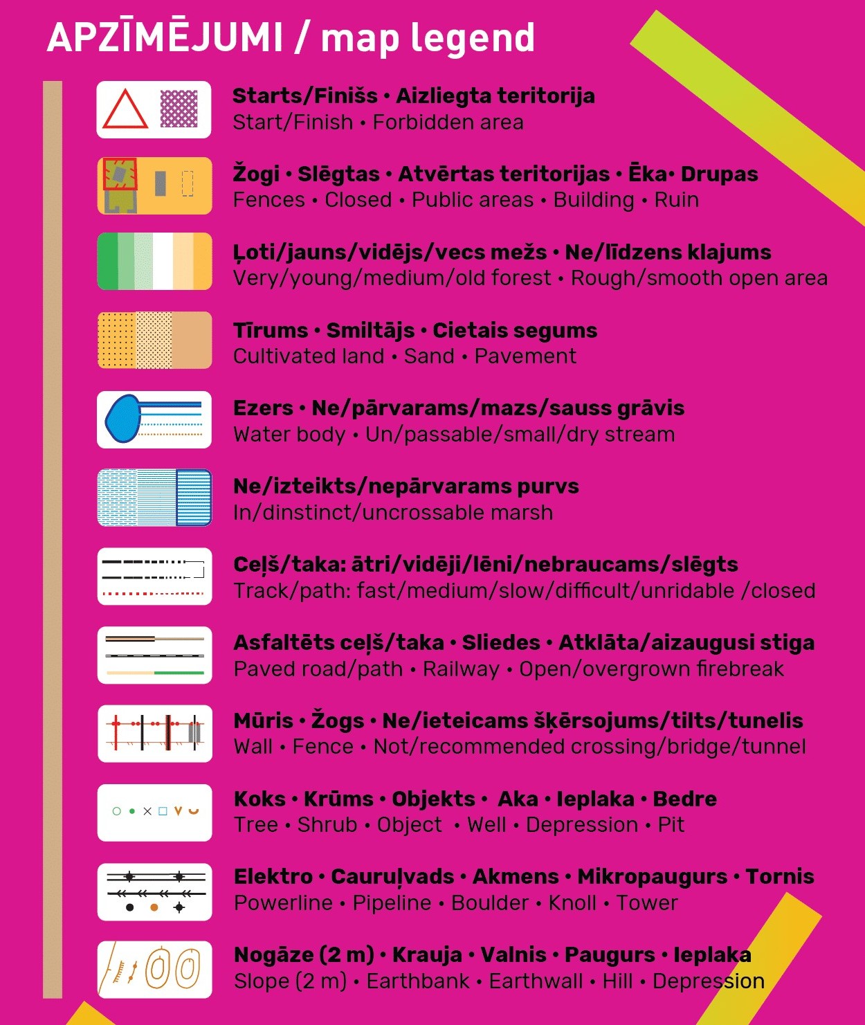
Since this year in all stages you will also be able to ride a bicycle in the MTB group - for the convenience of cyclists, asphalted (brown) and unasphalted fast/medium/slow/very slow (the more bumpy, the slower) black roads and trails will be sorted on the map. The tracks of the tractor equipment shown with the narrow stiga symbol will be useless for cyclists, but pedestrians can try to get out.
Already last year, we tried representing the vegetation as close as possible to the gradual transitions observed in nature from very young to young, to medium and old forest, using 4 different colors: green, lighter, very light and white, which orienteers are already used to on their maps. But this time they will not represent the runability, but only the age of the forest stand. Such a finer representation of the forest is possible thanks to the laser point cloud data published by the Latvian Geospatial Information Agency, which can be downloaded for free and map layers can be generated from them.
We remind you that the areas marked with olive green in the standard orientation signs are closed to participants. On the other hand, we painted the closed roads red. Even if it is not marked on the map, but you see a "Private property" or "No entry" sign in nature, please follow it and choose another path. Of course, first of all, the organizers themselves will try to plan the checkpoints in such a way that reaching them does not affect the rights of private owners.
The height curves will be with a relatively fine step of 2 m, so that you don't accidentally jump to the highest "mountains" of Riga, but appreciate them from the foot to the very top.
COMPETITION MAP AND AREA
Participants receive a race card when registering in the registration tent on the morning of the race. The cards will be moisture resistant, but each participant is responsible for keeping the card in wet conditions. The scale of the map is 1:20,000 or 1 cm = 200 m in nature. Size 62 x 43 cm (take this into account when choosing a bike card holder).
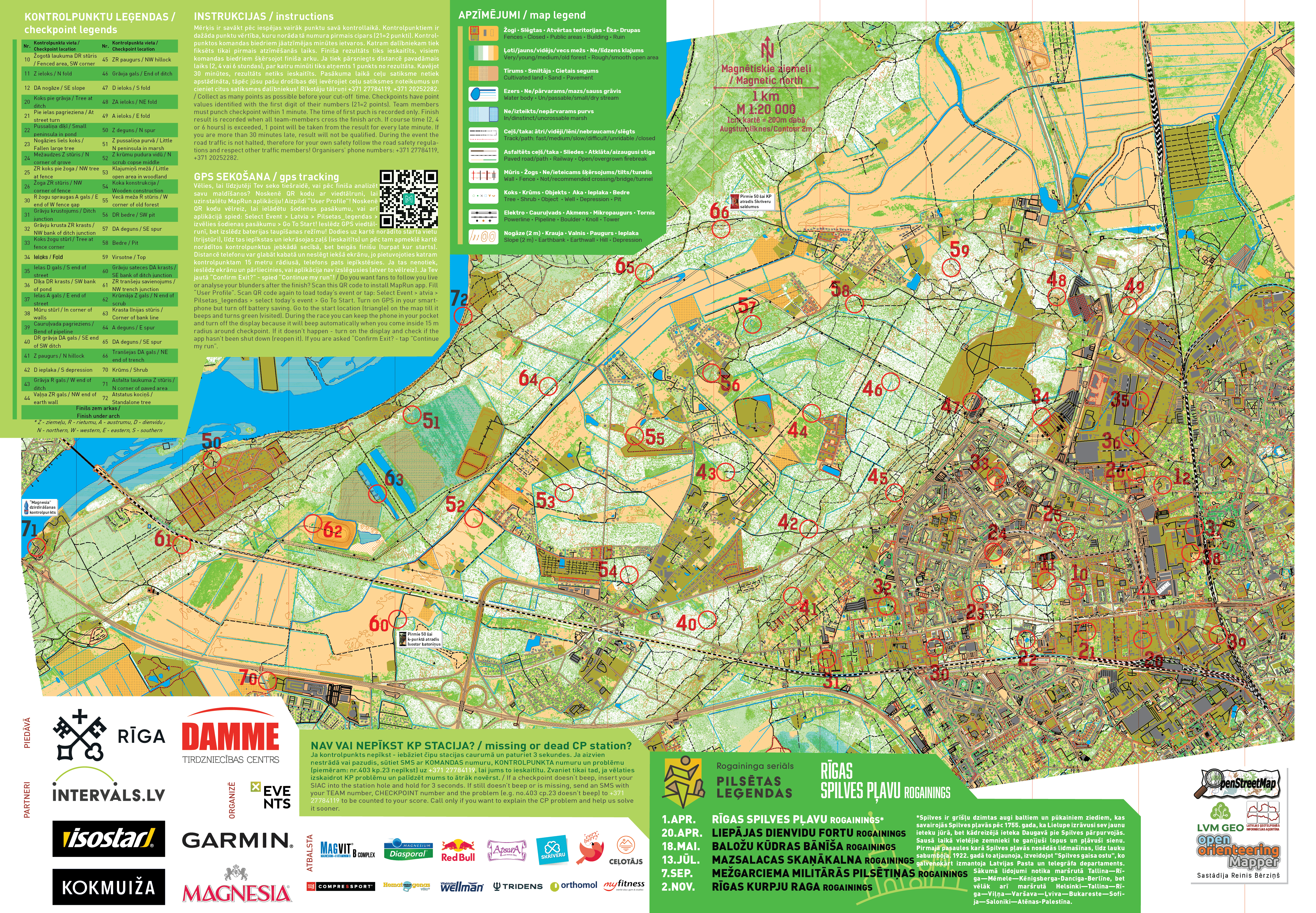
CONTROL DESCRIPTIONS
Familiarize yourself with checkpoint legends or location descriptions! Although in any case you should look for an object located in the center of the circle, the legends explain more precisely whether you should look for the north or south side of the building, etc. Some of the locations of the checkpoints are so legendary that we had to decipher them in order not to remember them ahead of time. Tomer You can try to remember them even now. You will find out the correct answers on April 1 before the start, when you receive a card with checkpoints.
| Nr. | Kontrolpunkta vieta / Checkpoint location | Nr. | Kontrolpunkta vieta / Checkpoint location |
| 10 | Žogotā laukuma DR stūris / Fenced area, SW corner | 45 | ZR paugurs / NW hillock |
| 11 | Z ieloks / N fold | 46 | Grāvja gals / End of ditch |
| 12 | DA nogāze / SE slope | 47 | D ieloks / S fold |
| 20 | Koks pie grāvja / Tree at ditch | 48 | ZA ieloks / NE fold |
| 21 | Pie ielas pagrieziena / At street turn | 49 | A ieloks / E fold |
| 22 | Pussaliņa dīķī / Small peninsula in pond | 50 | Z deguns / N spur |
| 23 | Nogāzies liels koks / Fallen large tree | 51 | Z pussaliņa purvā / Little N peninsula in marsh |
| 24 | Mežaudzes Z stūris / N corner of grove | 52 | Z krūmu pudura vidū / N scrub copse middle |
| 25 | ZR koks pie žoga / NW tree at fence | 53 | Klajumiņš mežā / Little open area in woodland |
| 26 | Žoga ZR stūris / NW corner of fence | 54 | Koka konstrukcija / Wooden construction |
| 30 | R žogu spraugas A gals / E end of W fence gap | 55 | Vecā meža R stūris / W corner of old forest |
| 31 | Grāvju krustojums / Ditch junction | 56 | DR bedre / SW pit |
| 32 | Grāvju krusta ZR krasts / NW bank of ditch junction | 57 | DA deguns / SE spur |
| 33 | Koks žogu stūrī / Tree at fence corner | 58 | Bedre / Pit |
| 34 | Ieloks / Fold | 59 | Virsotne / Top |
| 35 | Ielas D gals / S end of street | 60 | Grāvju sateces DA krasts / SE bank of ditch junction |
| 36 | Dīķa DR krasts / SW bank of pond | 61 | ZR tranšeju savienojums / NW trench junction |
| 37 | Ielas A gals / E end of street | 62 | Krūmāja Z gals / N end of scrub |
| 38 | Mūru stūrī / In corner of walls | 63 | Krasta līnijas stūris / Corner of bank line |
| 39 | Cauruļvada pagrieziens / Bend of pipeline | 64 | A deguns / E spur |
| 40 | DR grāvja DA gals / SE end of SW ditch | 65 | DA deguns / SE spur |
| 41 | Z paugurs / N hillock | 66 | Tranšejas DA gals / NE end of trench |
| 42 | D ieplaka / S depression | 70 | Krūms / Shrub |
| 43 | Grāvja R gals / W end of ditch | 71 | Asfalta laukuma Z stūris / N corner of paved area |
| 44 | Vaļņa ZR gals / NW end of earth wall | 72 | Atstatus kociņš / Standalone tree |
| Finišs zem arkas / Finish under arch | |||
| * Z - ziemeļu, R - rietumu, A - austrumu, D - dienvidu / N - northern, W - western, E - eastern, S - southern | |||