
Riga Spring Rogaining 2018 — pre-start information

Information about parking spaces, the new marking chip and other useful information to make the competition more comfortable.
Original publication date: 20.03.2018
PARKING ON RACE DAY
In cooperation with t/p Alfa, we will provide our participants with parking spaces on the 3rd and 4th floor of t/p Alfa free of charge and with time limits. We invite 2h participants to use the parking spaces available in other places, so that 4h and 6h participants can leave their cars on the 3rd and 4th parking floors. 2h should be enough time for the participants to start, wait for the award and return to their car.
NEW! SIAC AIR - CONTACTLESS TAGGING CHIPS = LESS LINES
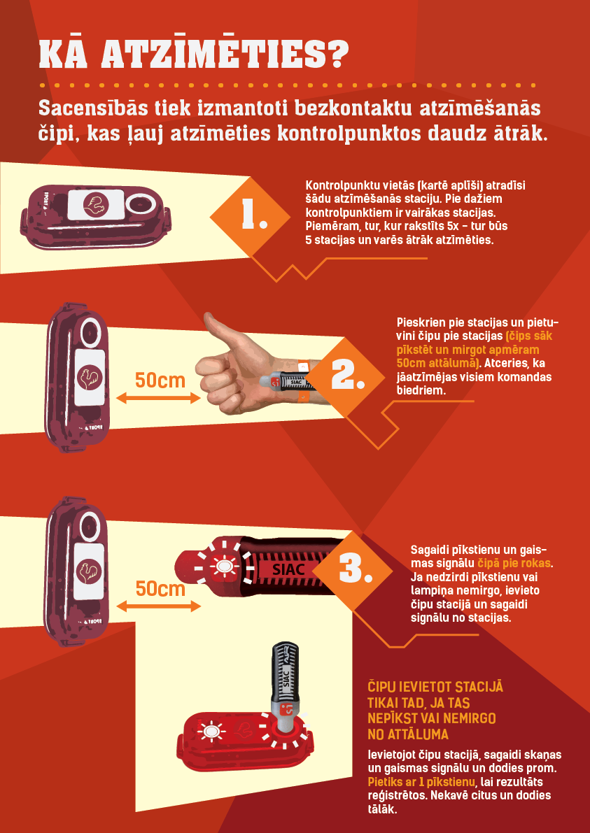
New this year are wireless tagging chips. If in the last competition the chip had to be placed in the station, then this time it will only have to be brought closer to the station. At a distance of about 50 cm, you will hear a beep and a light signal in your chip on your hand, which means that the tagging is successful.
Those who are used to it run past the station and then put their hand with the chip to their ear and make sure they hear the beeps. The chip reacts in a flash, so even if you run quickly past the station, it will record the result (unless you are the first at the station - then you have to insert the chip into the station).The competition center will also have test stations where it can be tested.
If you do not hear a beep in the chip, then you need to insert the chip into the station and wait for a signal from the station. This can happen in very rare cases and also if you are the first one at the station. The station after putting on will be "iemigusi" and the first one has to wake her up. It must be a good feeling when you run up to the station and find out you're first and "pamodini" to all their other members.
The number of stations at the checkpoint indicated on the map is also new. Thus, we encourage you to go first to those places where the number of check-in stations is greater and the queues are shorter. We believe that with the new SIAC AIR contactless chips there will be almost no queues. The notation will be as follows:

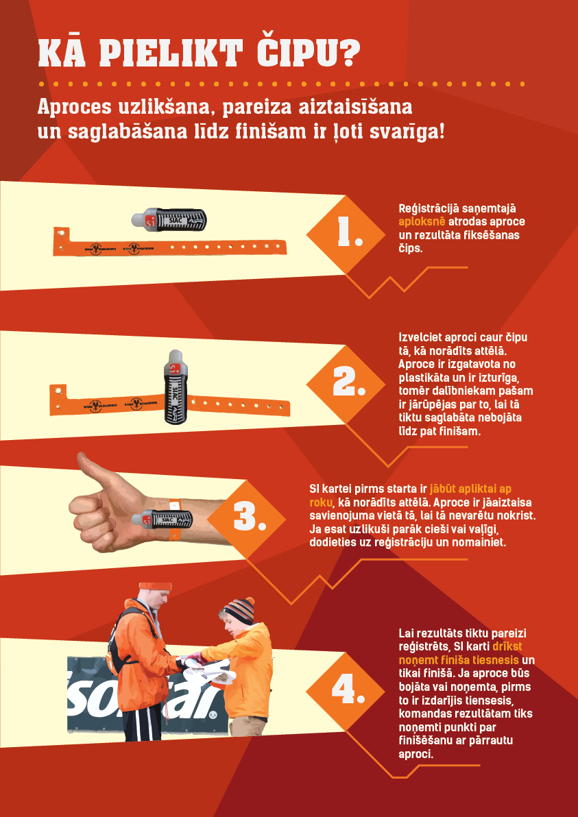
Below is how to attach the SIAC chip to your hand and how to mark it.
INSTRUCTIONS AND KEY INFORMATION (WILL ALSO BE ON THE MAP)
The goal of the competition is to collect as many points as possible in a given time. Checkpoints have a different point value, which is indicated by the first digit of its number (21=2 points).
The finish score will be counted only after all teammates have checked in at the finish checkpoint located under the arch. At the finish, it will be checked whether the wristband is intact and only then the participant may remove the SI card.
If the checkpoint cannot be found or is not working (stolen/damaged) in the distance, send an SMS with the TEAM number and the specific CHECKPOINT number (for example - no. 403 kp.23) to +371 20011284. Only then will it be counted (when you call and say about a lost/damaged checkpoint, it will not be counted). After sending the SMS, you can continue the distance. If the KP was still in place or was not damaged - it will not be credited to the team.
The competition takes place in a city with active traffic. For your own safety, follow the traffic rules and respect other road users! Helplines +371 27784119, +371 25888832. In case of emergency, call 113.
If the time spent on the distance (2, 4 or 6 hours) is exceeded, 1 point will be deducted from the result for each minute. If you are 30 minutes late, the result will not be counted. At checkpoints, teammates must mark themselves within a minute. Checkpoints visited after the end of the check-in time are not counted.
COMPETITION CENTER AND SCHEDULE
The competition center will be located next to "Alfa" t/p, Brīvības gatve 382, Riga. You can see the exact location here - https://goo.gl/XSbTYe
The competition center will provide toilets, luggage storage, changing room tents for both women and men, number collection, receiving cards, first medical aid, awards, hot tea at the finish. Members will have the opportunity to purchase “Isostar” energy drinks, gels and bars, as well as the opportunity to purchase “Garmin” products and "OS Veikals" store products.
| Time | Activity |
|---|---|
| 9:00 | Numbers are drawn and cards are dealt |
| 11:00 | Start for 4h and 6h rogaining |
| 12:00 | Start for 2h rogaining, Rogaining walk and Rogaining run |
| 14:00 | The end of the time limit for the 2h distance and the Rogaining run |
| 14:15 | Lottery for 2h Rogaining, Rogaining Walk and Rogaining Run |
| 14:30 | Awarding for 2h rogaining and Rogaining run |
| 15:00 | The end of the time limit for the 4-hour distance |
| 15:30 | Awarding and lottery for 4h rogaining |
| 17:00 | The end of the time limit for the 6-hour distance |
| 17:30 | Awarding and lottery for 6h rogaining |
NUMBER WITHDRAWAL PROCEDURE
All team members must go to the reception desk to pick up the members' numbers, name the team and sign the registration protocol for receiving the numbers. The team captain cannot sign for other members. The team envelope will contain numbers, safety pins, SI cards (identities), a bracelet for attaching the SI card to the arm, as well as various special offers from supporters. For teams renting compasses, they are placed inside the team starter pack.
CHANGE OF TEAM, MEMBER OR NAME
During the week of the competition, including on the day of the competition, an additional fee of 5 EUR must be paid for changing the distance, team name or participant. All changes can be made on the day of the competition in the Registration and Info tent. Deleting a participant from the team or the team refusing to start is free of charge.
GETTING MAPS, PLANNING THE DISTANCE AND STARTING
race maps will be issued at registration along with team envelopes, so teams that need more time to plan the distance can arrive at the race center earlier and allow as much time as needed for planning. Registration will be open from 9.00 a.m. to 12.00 Separate planning cards are not provided. When receiving the cards, it is mandatory to read the instructions written on the card. There will be a place for planning in the big tent, you can also plan in your cars or elsewhere. One card per participant. Before the start, every participant must put the SI card on his arm with the help of a wristband and keep it intact until the finish. At the entrance to the start corridor, the referee must show the SI card attached to the arm with a wristband.
MAKING THE DISTANCE
Since road traffic in the city of Riga is not closed during the competition, all participants are obliged to follow the Road Traffic Rules, to be especially careful when crossing the streets and at traffic lights. When finding a checkpoint, all team members must mark themselves at the point - wait for the signal in the chip at hand, or insert the chip into the station. Team members must mark themselves at checkpoints within 1 minute, otherwise the checkpoint will not be counted. The team must mark itself at the finish checkpoint by the end of the time limit of the selected distance. Checkpoints visited after the end of the time limit will not be counted. At the finish, judges must hand over SI cards and rented equipment. The results for the teams will be visible electronically on the screen in the competition center in the big tent, also available from mobile phones by visiting the competition website.
FOR SAFETY AND CONSIDERATION
Be careful everywhere you go! It is mandatory to follow the Road Traffic Rules for pedestrians! Do not run across busy roads in places not intended for this, causing motorists to have a negative opinion of athletes and lovers of active recreation! Follow the signs “Privātīpašums”, "Walking prohibited!"! Respect other residents and private owners who are the owners, but you are a guest!
CREW DISTANCE
We recommend choosing light, sporty clothes, comfortable shoes in which you can walk or run both in the city and in the forest. Mandatory equipment for each team is a charged mobile phone. Recommended distance equipment for all teams is a marker for distance planning, compass with degree divisions, ruler, watch, energy food and drink.
RACE MAP
The cards will be double-sided laminated and moisture-proof, but each participant is responsible for keeping the card in wet conditions. The total number of checkpoints - 50, the total value of points - 200 points. Checkpoint values from 2 to 6 points (the value of a point is the first digit of its number). The scale of the map is 1:20,000, or 1 centimeter on the map is equal to 200 meters in nature; card size: 62 x 42 cm. The map was prepared based on the topographical materials of the publication “Jāņa Sēta”, corrections in nature - Reinis Bērziņš. The map uses the designations of topographic maps, the terrain is depicted. To view the preliminary race map, press here.
DISTANCE DESCRIPTION
For the most interesting places, where it would be worth returning after the competition, we have written down the names on the map, which you can type in an internet search engine and read what the students were looking for 100 years ago on the Šampaniėš hill or where Riga used to store its heat (in the form of peat briquettes). Maybe you too will come to the same conclusion as us, that Riga is much bigger, more beautiful and more interesting than it seemed until now.
Even in the coming spring months, it is possible to reach all checkpoints on dry feet, as long as you manage to avoid mud and puddles and if you do not choose the most direct route.
As in the city, most of the land belongs to a private owner, which would be considered a prohibited area in classical orienteering competitions. In order not to paint the entire map red and not have to disqualify almost all the participants, we invite the participants themselves to be sober and not interpret the inscription "Nepiederošiem ieeja aizliegta" as an invitation to visit the security. We have also placed checkpoints in such a way that crossing such areas would not be profitable. On the other hand, pedestrians of more alternative routes can understand such inhospitable areas from the map just like fences.
The basis of the map is the usual "Jāņa Sētas" city map, where the forest is green, but the open spaces are white (as in the "normālās" maps for "normāliem" people, not as in the maps of a sworn orienteer, where the forests are white because they had to save green ink).
The terrain is obtained from an airplane by scanning the earth's surface with a laser. However, we did not fly ourselves, the Latvian Geospatial Information Agency did it for us, but the laser points were interpreted by the Latvian State Forests. If you see 2 brown contour lines next to each other on the map, one will be 2 meters higher than the other in nature. And if the hillside has 5 elevation curves, how many meters high will the hillside be? Wrong - 8 meters!
To make it easier to orient the compass, magnetic north lines (which must coincide with the north arrow of the compass) are drawn across the entire map. These lines are placed every 5 centimeters or 1 kilometer in nature.
Many additions and corrections have been made to the map, especially for rogaining purposes, but consider that it is impossible to fully survey such a wide area and you may come across some changes not marked on the map.
Recommended crossings over major streets, highways, railways and ditches (crosswalks, bridges, tunnels, beaver dams, fallen trees) that we recommend participants use are marked in red. We do not recommend crossing highways in other places, because then you may have to wait up to 10 minutes before a gap appears in the flow of cars.
As in the city, fences are everywhere. Only those fences that the participants will definitely run into are marked on the map. If you plan a more alternative route, where the fences are not marked (this does not mean that they will not be there), then you can guess their existence from the map:
- multi-storey
 or public building
 - generally unfenced, publicly accessible territory,
- mansion
 and industrial construction
 - usually a fenced, publicly inaccessible area.
If a gate is marked in the fence, it means that it is allowed to stay there. In addition, some checkpoints are deliberately placed in fenced areas, where the movement of participants has been allowed by their owners.
Separated in map designations  "pārvarami" and
 "nepārvarami" ditches and rivulets. In the Rogainist language, "pārvarams" means - jumpable or wadeable to the road (if you are the same height as the particular surveyor and cross in the same place. On the other hand, "nepārvarams" means - you will have to open the swimming season. Crossing places for impassable ditches are marked on our predicted participants' routes. Unfortunately, ditches have not been checked along the entire length, and fans of alternative routes can hope for some surprise from a beaver or disappointment All the marked ditches have water, while the dry ditches were not drawn on the map at all.
LEGENDS OF CHECKPOINTS (WILL ALSO BE ON THE MAP)
| No. | Checkpoint location | No. | Checkpoint location |
|---|---|---|---|
| 20 | Ditch juntion, N bank | 45 | Earthwall curve |
| 21 | Dīkis, SW bank / Pond, SW bank | 46 | Nose, SW end / Spur, SW end |
| 22 | Fence corner, E side / Fence corner, E side | 47 | Building, NW corner / Building, NW corner |
| 23 | Fence curve, A side / Fence curve, E side | 48 | Nose, D end / Spur, S end |
| 24 | Top | 49 | Lake, SW bank / Lake, SW bank |
| 25 | Fence curve, W side | 50 | Between Z and D lakes / Between N and S lakes |
| 26 | Top | 51 | Fence, NW corner / Fence, NW corner |
| 27 | Coapse, S end | 52 | Top |
| 28 | Nose, D end / Spur, S end | 53 | Lake, SE end / Lake, SE end |
| 29 | Open area, NE corner / Open area, NE corner | 54 | Depression |
| 30 | Ieloks, DA corner / Fold, SE corner | 55 | Nose, N end / Spur, N end |
| 31 | NE slope / NE slope | 56 | Top |
| 32 | Spur in forest, N end | 57 | Fold |
| 33 | Puduris, SW corner / Coapse, SW corner | 58 | Top |
| 34 | Top | 59 | Nose, D end / Spur, S end |
| 35 | Kuduris, N corner / Coapse, N corner | 60 | Pole remains / Pole remains |
| 36 | Top | 61 | Peninsula / Peninsula |
| 37 | Lītītis, D bank / Bay, S bank | 62 | Nose, NW end / Spur, NW end |
| 38 | Ditch junction, E bank | 63 | Fold |
| 39 | Z horn / N cape | 64 | Lake jetty / Lake jetty |
| 40 | River, N end | 65 | Path junction / Path junction |
| 41 | Nose in open area, Z end / Spur in open area, N end | 66 | DA bay / SE bay |
| 42 | Top | 67 | Nose, NW end / Spur, NW end |
| 43 | Ride junction / Ride junction | 68 | Top |
| 44 | Earthwall curve | 69 | Riverbank slope |
| Finish under the arch / | |||
| Finish under arch | |||
SAMPLE RACE CARD
